Investigated Landslide Activity in Three Gorges Area
Eight students – six undergraduates and two graduates – returned from spending six weeks in China, as part of a National Science Foundation International Research Experience for Students. This program was a U.S.-China collaboration between the University of Houston and the China University of Geosciences (CUG).
Guoquan “Bob” Wang, an associate professor in the Department of Earth and Atmospheric Sciences, was the UH faculty supervisor for this trip, collaborating with CUG faculty members Huiming Tang, Hanwen Zhou and Changqian Ma.
Huangtupo Landslide in the Three Gorges Region of China
While in China, students worked with a team of UH and CUG faculty members, students, and engineers, taking measurements of the Huangtupo landslide site, which is a slow-moving landslide that is creeping towards the Three Gorges reservoir.
“I was shocked to see the devastating effects of the Huangtupo landslide to the daily lives of local people,” said Benjamin Miller, one of the UH undergraduate students on the trip. Other participating students from the UH’s Department of Earth and Atmospheric Sciences were Jennifer Welch, Wanda Crupa, Valerie Smith, Janice Navarro and Jacob Kratavil. Robert J. Abel, a student from UH’s media production and communication department, and Katherine Sorrows, a geology undergraduate from Earlham College, also participated in the program.
With an area of 1.35 km2 and a volume of 70 million m3, the Huangtupo landslide is the largest within the Three Gorges region. To put that into perspective, 1.35 square kilometers is the size of 189 soccer fields, while 70 million cubic meters could fill 28,000 Olympic-size swimming pools. The landslide is estimated to move at a rate of 3 cm per year, although that rate is still under debate.
Observational Tunnel Offered View of Landslide

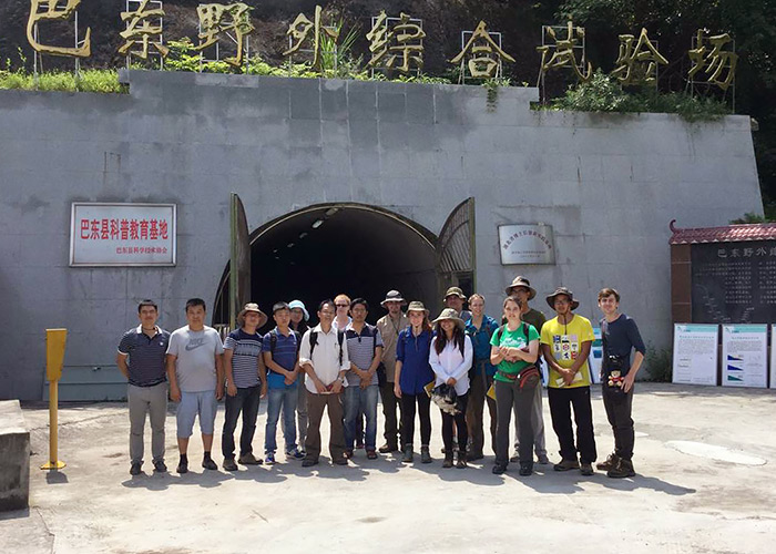
The landslide surveying team poses in front of the tunnel crossing the Huangtupo landslide.As part of the ongoing efforts to understand the impact of this landslide, CUG constructed
a monitoring and observational tunnel that is nearly 1 kilometer in length and includes
5 branching tunnels with 36 observation windows. Students were given the opportunity
to walk inside this tunnel and observe the landslide happening in actual time.
“We were able to see the effects of the damage from the landslide. The corridors within the tunnel, which had been built flat and straight, were wavy and cracked from the weight of the landslide,” Welch said. “We were also able to see the slip zone of the landslide,” Kratavil added.
LiDAR Measurements Offer 3-Dimensional Information about Landslide Activity

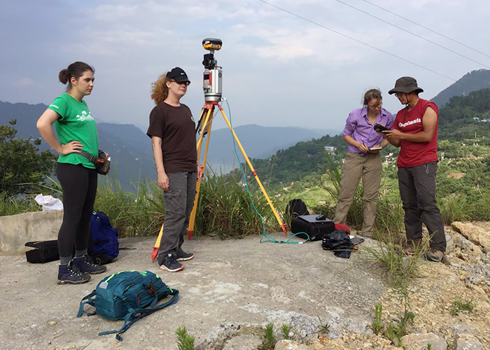
Students scanning the Huangtupo landslide using ground-based LiDAR.During the fieldwork portion of the trip, students assisted with LiDAR measurements
of the landslide. LiDAR, also called 3D scanning or laser scanning, can produce high-resolution
3D maps. Over time, LiDAR measurements can provide insight into the rate at which
the landslide is moving.
“For me, the interesting part of this trip was observing the methods used in the field. The new LiDAR techniques allow us to conduct high-accuracy and high-resolution surveying in a much faster way compared to the conventional land survey,” Kratavil said.
Fieldwork: Adjusting to the Unexpected
During the trip, students learned one of the cardinal rules of fieldwork – how to deal with unexpected complications.
“We were able to see how to finish a project within a specific time frame, even while adjusting to unexpected problems,” Miller said.
This meant adjusting to ongoing demolition within the Three Gorges region. During the time of the students’ fieldwork, the Chinese government was demolishing local buildings that had been rendered unsafe by the Huangtupo landslide, which meant the group needed to readjust their onsite research strategy.
“We always say that ‘The field schedule is dynamic!’” Wang said. “Out in the field, many things are out of our control. Fieldwork requires making a plan with a firm goal but a flexible schedule.”
- Rachel Fairbank, College of Natural Sciences and Mathematics