University of Houston (UH) professors and students are taking part in an air quality
study that will help scientists understand how to better interpret and forecast air
quality using satellite data and numerical models. 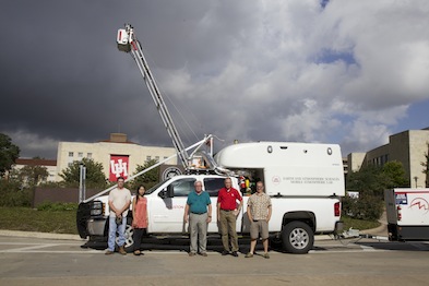
Throughout September, mobile labs, ground instruments, airplanes and a satellite,
took Houston air quality measurements. UH atmospheric scientists Barry Lefer, Robert
Talbot and Yunsoo Choi, as well as adjunct professor Gary Morris, worked together
alongside 15 undergraduate and graduate UH students. The effort is part of a multi-year
NASA air quality study – DISCOVER-AQ – that also includes measurements in Washington,
D.C., Baltimore, Los Angeles and Denver.
“Satellites measure the total amount of pollution in the atmosphere, so the readings
get the upper level pollutants that don’t affect us as much, as well as the lower
level pollutants,” said Lefer, associate professor in UH’s Department of Earth and
Atmospheric Sciences. “The trick is how to subtract off the stratosphere to get to
the measurements you want.” 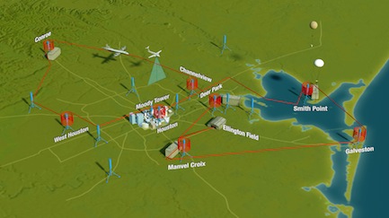
Lefer says mobile and stationary measurements, a plane with downward views simulating
satellites and a plane getting vertical profiles by spiraling between altitudes will
be compared with what a satellite gets for the same day. The satellite measurements
come from a fleet of Earth-observing satellites, called the Afternoon Constellation
or “A-train,” which passes over Houston each day at 1:30 p.m.
“UH has two mobile labs, instrumentation at six of the 15 ground sites and daily weather
balloon launches that gather ozone measurements,” Lefer said. “We also are hosting
several monitoring devices from other universities on our rooftop lab atop the Moody
Towers residence hall, as well as in our mobile labs.”
Up in the air, one of the NASA planes flew at 26,000 feet, taking downward gaseous
and particulate measurements mimicking a satellite. The other plane flew a similar
route at lower altitudes and also made spirals around eight locations, sampling the
air at various levels over those sites.
“The sampling area covers the Houston metropolitan area, ranging from Conroe in the
north to Galveston in the south. The flight path is sort of a figure-eight shape,”
Lefer said. “The planes flew the route three times each flight day. With 10 to 13
flight days, we’re going to have good statistics, with some flights occurring on clean
air days and some on dirty days.” 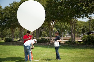
At Moody Towers, Talbot’s instrumentation measured carbon dioxide, methane and mercury,
and Lefer measured ozone, formaldehyde and four other pollutants. Choi’s air quality
forecasting model helped the NASA project team reach its decision each afternoon on
whether to fly the planes the next day. Morris launched weather balloons outfitted
with ozone-measuring equipment each day from campus.
“The results of this study are going to help us get a better understanding of what
the satellite is showing us,” Lefer said. “If we are better able to interpret satellite
data, then we can make more accurate air quality analyses and forecasts. And, that
will have a big impact on human health.”
UH’s participation is funded by grants from the Texas Air Quality Research Program
and the Texas Commission on Environmental Quality.
###
About the University of Houston
The University of Houston is a Carnegie-designated Tier One public research university
recognized by The Princeton Review as one of the nation’s best colleges for undergraduate
education. UH serves the globally competitive Houston and Gulf Coast Region by providing
world-class faculty, experiential learning and strategic industry partnerships. Located
in the nation’s fourth-largest city, UH serves more than 39,500 students in the most
ethnically and culturally diverse region in the country. For more information about
UH, visit the university’s newsroom.
About the College of Natural Sciences and Mathematics
The UH College of Natural Sciences and Mathematics, with 193 ranked faculty and nearly
6,000 students, offers bachelor’s, master’s and doctoral degrees in the natural sciences,
computational sciences and mathematics. Faculty members in the departments of biology
and biochemistry, chemistry, computer science, earth and atmospheric sciences, mathematics
and physics conduct internationally recognized research in collaboration with industry,
Texas Medical Center institutions, NASA and others worldwide.
To receive UH science news via email, sign up for UH-SciNews.
For additional news alerts about UH, follow us on Facebook and Twitter.