
3D Outcrop Imaging
3D Outcrop Imaging
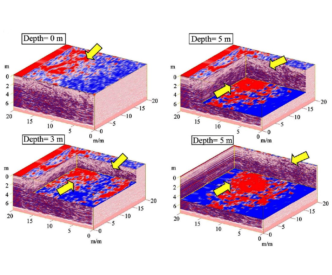
Our ongoing research is integrating high resolution, geometrically accurate terrestrial laser scanning (TLS), unmanned aerial vehicle (UAV) photogrammetry, and high resolution, spectrally accurate hyperspectral imaging for the study of geological outcrops. The ground-based hyperspectral imaging can scan the objects at close range, thus providing very fine spatial resolutions (millimeters to centimeters), while UAV and TLS provide 3-D photorealistic modeling of outcrops using robust analyses and visualization environments. We are using these techniques for petroleum reservoir analog studies and understanding of geological processes at several locations, including Cement Oilfield (Anadarko Basin), Oklahoma; Wingate Sandstone and Ferron Sandstone, Utah; Eagle Ford Formation, West Texas; Carbonate rocks of Edwards Formation; Mississippian limestone in Arkansas; and mafic-ultramafic rocks of Semail ophiolite, Oman.
Photographs
Publications
Shahtakhtinskiy, A., Khan, S. D., 2020. Quantitative analysis of facies variation using ground-based lidar and hyperspectral imaging in Mississippian limestone outcrop near Jane, Missouri, Interpretation, 8(2), 1–14 https://doi.org/10.1190/INT-2019-0151.1
Biber, K., Khan, S. D., Seer, T. D.,Sarmiento, S., Lakshmikantha, M. R. 2018. Quantitative characterization of a naturally fractured reservoir analog using a hybrid lidar-gigapixel imaging approach. Geosphere, 14(2),1-21; https://doi.org/10.1130/GES01449.1
Sun, L., Khan, S. D., Sarmiento, S., Lakshmikantha, M. R., Zhou, H., 2017. Ground-based hyperspectral imaging and terrestrial laser scanning for fracture characterization in the Mississippian Boone Formation. International Journal of Applied Earth Observations and Geoinformation, 63, 222-233, https://doi.org/10.1016/j.jag.2017.08.008
Okyay, U., Khan, S. D., 2016. Remote detection of fluid-related diagenetic mineralogical variations in the Wingate Sandstone at different spatial and spectral resolutions. International Journal of Applied Observation and Geoinformation, 44, 70-87. https://doi.org/10.1016/j.jag.2015.08.001
Hartzell, P., Glennie, C., Biber, K., Khan, S. D., 2014. Application of Multispectral LiDAR to Automated Virtual Outcrop Geology. ISPRS Journal of Photogrammetry and Remote Sensing, 88, 147-155. https://doi.org/10.1016/j.isprsjprs.2013.12.004