Flooding History
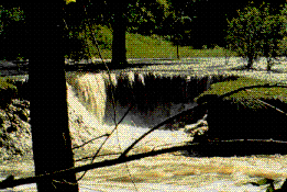 Cascading floodwaters gnaw away at the Lower Cottonwood Campground below the emergency spillway at the U.S. Army Corps of Engineers' Coralville Lake in Johnson County on July 7, 1993 ( U.S.G.S.).
Is it possible to predict the probability of an event of this magnitude? If you buy a piece of property near the banks of a moderate sized river would you know what questions to ask to learn the history of that particular drainage basin? You learn that a 100-Year flood took place three years ago. Should you feel safe because it will be at least another 97 years before an event of that magnitude will take place? What background should you have to be able to understand the information that you may find?
Predictions of frequency of flooding are based on stream guaging records using the annual maximum
discharge, or the highest value measured at that station for a given year. A 15 year history for a gauging stating along the Diamond River at Wentworth, New Hampshire is given in the table that follows.
Maximum Annual Discharge Along The Diamond River at Wentworth, New Hampshire
| Year | Maximum Annual
Discharge (cfs) |
|---|
| 1982 | 4,600 |
|
| 1983 | 6,500 |
| 1984 | 8300 |
| 1985 | 7250 |
| 1986 | 6,000 |
| 1987 | 5,200 |
| 1988 | 8,000 |
| 1989 | 4,500 |
| 1990 | 5,000 |
| 1991 | 4,200 |
| 1992 | 9,400 |
| 1993 | 3,600 |
| 1994 | 5,800 |
| 1995 | 4,000 |
| 1996 | 4,700 |
The hydrologic community uses a water year which extends from October 1 of one year to September 30 of the following year. Thus, a flood that occurs on October 1, 1999 is recorded in the year 2000. All of the data in this exercise have been recorded in hydrologic years.
Our goal is to study the variation of maximum annual discharge over time and to see if we can devise a prediction scheme.
Perhaps you can visualize the variation in the maximum annual discharge over time. A histogram or bar diagram is constructed with time (years) on the horizontal axis (the X-Axis). Maximum annual discharge is plotted on the vertical axis (the Y-Axis). The height of the bar is equal to the maximum annual discharge for that year.
To get started with our analysis of the maximum annual discharge along the Diamond River, New Hampshire, a plot of maximum annual discharage is prepared. Remember that these are the same data that were previously depicted in histogram form.
Maximum Annual Discharge As A Function Of Time
Sometimes it helps to connect the Y-values (maximum annual discharge) for consecutive years by straight line segments. This produces what is called a time series. Keep in mind that only one point was chosen per year - the Maximum Annual Discharge.
The Rating Curve - Stage versus Discharge
These data were obtained from the United States NWIS-W Data Retrieval web site.
- Click on New Hampshire (or the state you are interested in)
- Click on a list of all stations
- Click on the station of interest
- Indicate that you want the data as tab-delimited, that you want the maximum annual discharge and that you want the format to be MM/DD/YYYY (month, day and year).
- Request the data set
- Some of the newer browsers will not save these files properly. What you can do is either write down the year (the 3rd column) and the discharge (the 4th column) and enter the data in a spreadsheet application like Excell. Or, select the data by holding down the mouse button and dragging from the top line to the bottom line. Paste the data into a word processing file and save as a text file. Open Excell and indicate that the delimiters (the indicator of when one field stops and the other begins) are blank spaces. You should be able to import the data into the spreadsheet application.
Return