Statement of the Problem
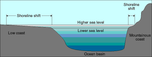 The slope of a shoreline plays a critical role when considering the effects of a rise (or fall) of sea level. If the shoreline has a gentle dip then a relatively small rise will cover a considerable distance. When the shoreline is steep, however, the area affected is considerably reduced. The area under investigation has a very gentle dip away from the land area. [U.S. Geololgical Survey]
Condos-R-Us bases their claim on a report titled Shoreline Changes in the Vicinity of the Brazos River Delta by Morton and Pieper published in 1975 by the Bureau of Economic Geology, The University of Texas, Austin, Texas. This major investigation was undertaken by Morton and Pieper to study the rates of shoreline change from 1852 to 1974.
A copy of a portion of their map is given below.
Areas shown in Yellow have a 122 year erosion rate that is positive. That is, these areas are undergoing accretion as measured over the total time interval.

The small map below shows the locations studied by Morton and Piper. The Condominium site is close to station 18.
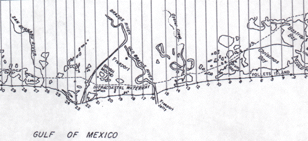
A copy of an aerial photograph of the area between the Old Brazos River and the current Brazos river is given below. The Condominium site is marked.

An Analysis of Shoreline Changes in the Vicinity of the Proposed Condominium Site
-
As noted in a previous section, the behavior of the shoreline is a function of long-term, short-term, and episodic changes. Overall, this section of the Gulf Coast is undergoing a transgression - sea level rise. Sands are delivered to this section of the coast by the offshore current and by the Brazos and San Bernard Rivers. Note, from the map, that the Freeport Jetty was constructed in 1909.
- 1852 to 1930
- 1930 to 1956
- 1956 to 1965
- 1965 to 1974
Explore some relationships in the Morton and Pieper's data set.
Up until 1929, the Brazos River entered the Gulf of Mexico just east of station 16 and had formed a rather sizable delta. The modern Brazos River delta is an arcuate, wave-dominated delta that protrudes 2 km into the Gulf of Mexico. It began forming in 1929 when the Brazos River was diverted from the Freeport channel to its present location. Morton and Pieper's data are presented for several time intervals:
Shoreline Changes at Station 18
-
You have access to their data for Station 18 . Reconstruct the data set for this one station. Pay particuar attention to changes in erosion/accretion rate over time.
Shoreline Changes for Stations 10 - 30
-
Now that you have an understanding as to what has happened to the shoreline at Station 18, it will be instructive to look at what has taken place in an area of about 15 miles of either side of this reference station ... Stations 10 - 30.
Your Recommendations
-
Now that you have had a chance to interact with some of the data, it is probably a good time to review before you make your recommendation(s).
- The importance of historical records can not be over emphasized. They provide a framework within which one can quantify changes and begin to interpret the causes of the observed effects.
- Care, however, must be taken in deciding if it is appropriate to "lump" all of the information together during an interpretation. For example, the 122 year erosion/accretion rates suggest that Station 18, the proposed site of the Condominium Project, has undergone accretion at a rate of about 10 feet per year over that time period.
- Looking at the sub intervals of time that were available, however, suggests that Station 18 stopped accreting in 1930 (at an average rate of about 40 feet per year) when the Brazos River was diverted to the west. Since that time Station 18 has been undergoing erosion at a rate of about 50 feet per year which should cause great concern when Condos-R-Us proposes to erect a structure 400 feet from the shoreline.
- Given what you have learned, how will you vote - For the proposal to build or Against?