Sink - the physical, chemical and geologic setting of the site of deposition of the sediment
Sediment is converted to sedimentary rock by lithification:
- cementation - precipitation of a chemical cement that binds the individual particles together - effective with the coarser grained rocks and
- compaction - grains are forced together as a result of an increase in load pressure - effective with the finer clastic sedimentary rocks.
Diagenesis refers to the processes that act to modify the sediment and sedimentary rock after it is buried. Diagenesis may grade into metamorphism if the temperature and pressure increase sufficiently.
Classification of Sedimentary Rocks
Maturity of Sediments and Sedimentary Rocks
Recall from the chapter on Weathering that most of the common minerals react to form clay if the climatic conditions are favorable and if the source area is stable. Therefore, thorough chemical weathering of a granite (80% alkali feldspar, 15% quartz and 5% mica) may result in the formation of clays and a concentration of quartz. The greater that amount of quartz in a coarse clastic sedimentary rocks the higher the Mineralogical Maturity. If this granite were located at a convergent margin with accompanying earthquakes, turbidity flows, and other process of such an active area, it is likely that not all of the feldspar will be altered to clay minerals and a less mineralogically mature rock (like an arkose which is feldspar rich or a litharenite which is rock fragment rich) may form.
Consider the mixture of quartz and clay minerals. The clay minerals are very fine grained and a very weak slope agent (running water or the wind) may be able to suspend the clays leaving the quartz behind. Sorting is a set of processes which tend to concentrate particles of similar size. When the quartz grains are transported (water or wind) they tend to change in shape as a result of abrasion - like a giant rock tumbler, these grains bang together as they are transported and the sharp corners and edges are rounded. Feldspars cleave in two directions at 90 degrees. When feldspars (and many other grains) are transported they may not become rounded - they cleave and retain an angular shape.
Rocks which consist of coarse clastic grains of nearly the same size and contain quartz grains which are well rounded are supermature. A mixture of sand sized quartz grains with sharp corners and edges and clay minerals is immature . In general, the longer the time available for transportation, the more likely it is that the maturity of the sediment will increase.
Note that the two types of Maturity are measuring two different aspects of clastic sedimentary rocks. Mineralogical maturity measures the extent to which the unstable minerals have been destroyed by weathering whereas Textual maturity measures the availability of persistent currents which are needed to produce sorting and rounding of quartz.
This Glacial Tillite is very poorly sorted. At Galveston beach the currents continually pick up the sediment and carry the finer material off-shore and leave the coarsest material at the beach. With a magnifying lens you can see how rounded these grains are and that they are all about the same size. Along a shore line with stronger currents you may find a coarser beach deposit. Note, however, that the coarsest grains must be present in order to be concentrated. If, for example, a source area consists of a rock with 100% quartz grains which are well rounded, then the resulting sediment (assuming that no other material was mixed in) will contain 100% quartz.
Wind and water may produce mature sediments if the slope agents are persistent. Ice, on the other hand tends to be highly unselective and glacial deposits are characteristically poorly sorted and immature.
Porosity and Permeability
Two other aspects of sedimentary rocks that are significant are:
- Porosity - the percent of open space in the rock and
- Permeability - the extent to which the pores are interconnected so fluids can flow through the rock.
Note that a sponge is quite porous but water will not flow through it easily (unless you distort the sponge). Hydrocarbons and other liquids (like water) may be stored in rocks which are porous and permeable. If the permeability changes in a rock unit the fluids may be trapped creating a reservoir. Cementation typically reduces both the porosity and permeability of a coarse clastic rock. Shales and mudstones have low permeability but may have moderate porosity. Shales and mudstones may form permeability barriers which prevent fluids from escaping from a reservoir.
Shales and mudstones may contain partially decomposed organic matter (especially if they were deposited in a reducing environment) which can evolve to oil and natural gas with heating as a result of increased depth of burial. These rocks may be the source beds for hydrocarbons. However, if these units are heated to about 150 to 200 oC the hydrocarbons are broken down and all that is left is a residue of carbon. Thus, there exists an oil and gas window within the Earth. If temperatures are too low then hydrocarbons will not form. If they are to high the hydrocarbons are destroyed. It is the job of the petroleum explorationist to evaluate the thermal and burial history of a basin in order to predict the hydrocarbon potential.
Interpreting Sedimentary Rock Histories
The slope agents may leave their mark on individual grains and on the relationships between and within beds. The density of air is very small. Wind transported (aeolian) quartz grains easily move through the air and expend much of their energy on impact which produces small pits on each grain. As the extent of pitting increases these grains may take on a frosted appearance. The next time you are at Galveston look at some of the grains from the sand dune area immediately behind the beach. These grains tend to be smaller than the grains on the beach itself and most are frosted. If the beach and dune assemblage were buried and cemented, a geologist of the future would be able to deduce their environments of deposition by looking for clues such as these.
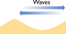
When you walk into the water from the beach you can usually feel the ripples which characterize the beach area. These symmetrical cusp-shaped ridges when buried will provide yet another clue as to the "paleogeography" of the rocks. Location of "ancient" beaches provides an important part of reconstructing the history of rock units as the beach (or other strand-line deposits) separates the continental from the marine environment. The symmetry of these "oscillation ripple marks" reflects the back and forth motion of the currents on the beach. Ripples formed by streams, on the other hand, produce asymmetrical ripples with the steep side pointing down slope and the gentle side up slope.
Many experiments have taken place in sedimentology (the study of sediment) laboratories. Imagine a tilted sandbox which is filled with fine sand. Water enters the stream table at the top and begins to flow down hill. If the velocity is very low the grains are not suspended but move back and forth beneath the water. One way to deposit thin beds (or laminae) is to have a very low velocity stream or wind involved in transporting the grains. As the velocity increases some grains are picked up and carried in suspension by the slope agent. When deposited these grains may be inclined with respect to a horizontal plane. These cross beds (or cross laminations) record the direction of transport - the beds "point" down stream. Other types of sedimentary features characterize other process which operate as part of the slope system. The computer can be used to simulate such experiments.
Sedimentary Structures
 Some features of sedimentary rocks can be used to determine which side of the bed was up when the bed was originally deposited; these are geopetal structures. For example, oscillation ripple marks (to the right) form on the top of beds deposited along a beach. The coarsest grains in a graded bed were deposited (most likely) on the bottom of the bed.
In the previous paragraphs a number of important clues for the interpretation of sedimentary rocks and the recreation of their history have been summarized. These clues (and many others) allow a geologist to extract the maximum amount of information from the rock record. However, recall that the rock record is not a complete record of the history of the Earth and rarely does the geologist have well exposed rock outcrops.
This animation of the migration of ripples on a sandy surface was constructed with the aid of the USGS program "Bedform 3.0" (http://walrus.wr.usgs.gov/seds/Movie_list.html). It shows a cross section through the ripples in the transport direction where you can see the development of cross bedding due to the combination of erosion on the stoss side and deposition on the lee side of each ripple. Note how the migration of the dunes to the right builds up the internal structures.
A Mental Field Trip
Imagine taking a "field trip" starting in the continental region and heading towards deep ocean basins. It is important to consider the preservation potential of sediment deposited in some setting along our traverse. In general, sediment deposited on land has a low preservation potential. The next flood or wind storm or glacier may pick up previously deposited material and move it along towards the ocean. Sediment deposited in a lake (lacustrine) may have a higher probability of being preserved.
Sediment can be transported to deep ocean water but the accumulation rate in such settings are relatively low. Most of the stratigraphic rock record on Earth consists of rocks originally deposited in the transition zone between continent and ocean. These depositional settings include deltas, beaches, barrier islands among others.
Sediment can be transported into the deep ocean water in two ways:
- Wind transported debris - when a volcano erupts much of the glass and solid fragments may be transported great distances and, recalling that about 72% of the Earth is covered with water, much of this debris may settle through the ocean water and eventually accumulate on the ocean bottom. When the small shelled animals that live in the water column die their shells also accumulate on the sea floor. This material is called the pelagic component.
- Debris transported rapidly down slope by a turbidity current may accumulate and in the form of submarine fans. These currents characteristically develop along active continental margins where earthquakes and volcanic eruptions may trigger the rapid under water down slope movement of debris that had been deposited in the transitional zone. Deposits formed in this way are called submarine fans as the debris will spread out as a fan shaped feature where the slope changes. In many ways an alluvial fan (continental) and a submarine fan (marine) are quite similar in terms of their origin.
Thus, two very different types of sediment may accumulate in deep ocean water. Coarse sandstones (often containing fossils of animals that lived on the continent) deposited by turbidity flows are overlain by fine grained deposits of glass, clay minerals and shells of marine animals. These deposits were difficult to interpret until direct observation in small submarines confirmed the existence of turbidity flows and the steep canyons that the flows create as they move sediment down the continental slope.
One other aspect of deep marine deposits that is significant is the absence of calcium carbonate when the water depths are greater than about 4,000 meters. In cold ocean water which is under high pressure, calcite goes into solution. Only in warmer, shallower water will calcite accumulate.
Sedimentary Facies
A traverse from the dune to the beach to the off-shore would reveal that there were three types of sediment. The continental sediment is coarsest, the beach sediment is finer and well sorted and the off-shore material is even finer grained. Imagine that sea level rises and the ocean moves inland. Assume that this is a long term rise in sea level and that the beach (the transition between continental and marine environments) "tracks" the rise in sea level. If sea level were to rise 50' "Galveston Beach" would be west of Houston. A relative rise in sea level resulting in an encroachment of the marine environment over what had been a continental environment is called a Transgression. Note that the same result would occur if the land subsided while the sea level did not fluctuate.
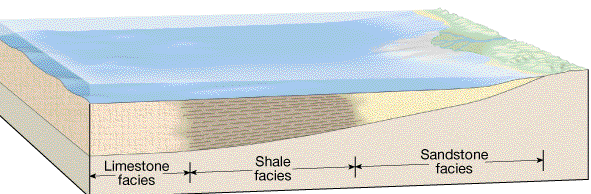
In the figure above the sandstone facies is coarse, the shale facies is medium and the limestone facies is fine in particle size.
About 20,000 years ago sea level was about 300' lower and the Galveston Beach was tens of miles off-shore. A relative drop in sea level resulting in the migration of the continental environment over what had been the marine environment is called a Regression. Note that the same result would occur if sea level remained constant but the land was uplifted.
Transgressions and regressions which are relatively short lived (a few thousand years) may be caused by glaciation. When glaciers are advancing sea levels tend to be lower. When glaciers are retreating sea levels rise. Many transgressions and regressions seem to have lasted for hundreds of thousands of years. This is too long to be accounted for by changes in climate resulting in periods of glaciation. These long terms rises in sea level are probably related to an increase in the rate of sea floor spreading. Rapid sea floor spreading (perhaps 10 cm per year) results in an enlargement of the mid oceanic ridge. The increase in the volume of the ridge causes ocean water to encroach on the land. Imagine a basin with a rubber bottom. If you push up on the bottom of the basin some of the water is forced out of the basin. If the rate of spreading slows down (perhaps 4 cm per year) the ridge occupies less volume and ocean water may move away from the continent.
Animation of the transgression and regression of marine sediments due to relative sea level change. Light blue waves: sea, drak blue bricks: reef limestone, yellow: conglomerate; red-black-white-green: sandstone-shale-mudstone sequence, pink dashes: basement.