|
|
|
Here are Some Other Useful Links
|
Ground Sites
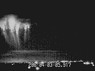
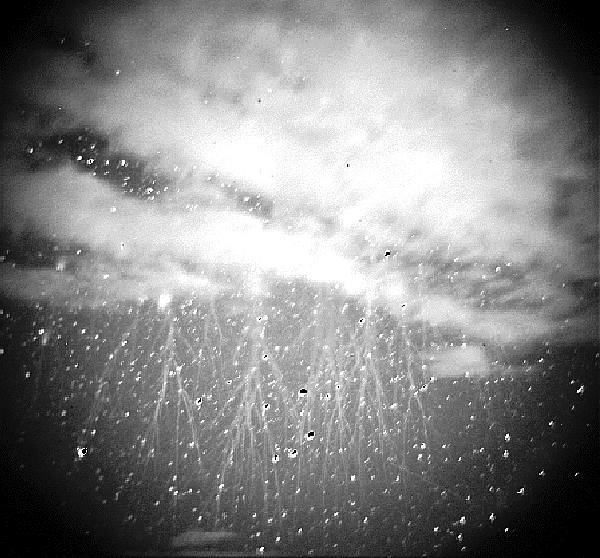
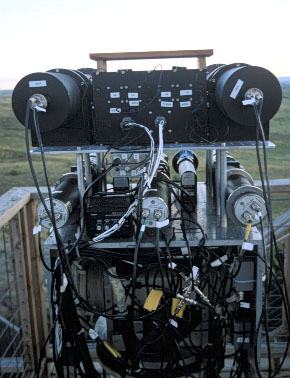
Ground-based Optical Observations:The task of calculating the electromagnetic field at the balloon that is predicted by the various models requires fairly precise knowledge of the timing, location and size of the emission being modeled. We propose to meet this requirement by making low-light-level video observations of the sprites, jets, and elves from three sites located on the eastern edge of the Rocky Mountains. Simultaneous multiple site video recordings will permit the use of triangulation methods to establish the location and size of the observed events. The observations will be carried out by the Co-Investigation teams from the Geophysical Institute at the University of Alaska and FMA Research. The University of Alaska group will operate low light level cameras from two ground sites separated by sufficient distance to allow accurate triangulation of sprties and other optical features. Since we will be using the star backgrounds for reference, the sites need to be as free of light contamination as possible. We propose to use the Wyoming Infrared Observatory (WIRO) atop Jelm Mountain, Wyoming (2943 m) and the Denver University Astronomical Observatory on Mt. Evans, Colorado (4313 m) where excellent data was obtained in previous operations in 1995 and 1996. Both ground sites will be equipped with a Trimble model Six-Vee 6 Global Positoning System (GPS) receiver to provide position and time. GPSD timing information will be recorded directly onto the video images using a Horita model GPS-2 smpte time code generator. A master sync generator at each using the GPS time will synchronize all camera systems to 32 s absolute. This method will allow accurate triangulation and comparison with balloon data. We will use one Dage-MTI VE-1000 SIT monochromatic camera at each site. They have a sensitivity of 1.6 x 10⁻⁷ W-m-2 at 550 nm and 300 lines resolution. The second camera at each site will be an intensified CCD camera using Fairchild CCD's. The sensitivity is comparable to the Dage-MTI Systems. We have a variety of focal length lenses for use as appropriate. Both sites will have access to real time satellite cloud data, and NLDN lightning data for assisting in the decision processes of launching the balloon and selecting storms to view with the camera. One site will also have a high speed photometer that is bore sited with the cameras. The low-light level cameras, which will be used for event identification, can time events to the closest TV field, or to 16.66 ms. In order to relate the optical emissions with the high bandwidth balloon data, closer timing is needed. This timing will be provided by use of a photometer. A high speed photometer system has been developed for auroral research by one of the Co-Investigators, Hans Stenbaek-Nielsen, in conjunction with Major Geoff McHarg of the air FOrce Academy. The system, as presently configured, consists of a 200 mm, 5" circular aperture reflector lens with a 25 mm Hamamatsu photomultiplier. The maximum field of view is 7.2 degrees. Aperture plates can be inserted in the image plane to provide different field of views. The photometer system is controlled by a computer and the output of the photomultiplier is recorded on disk. The time resolution of the output can be varied up to 110,000 samples per second. Wyoming Infrared Observatory
The Wyoming Infrared Observatory (WIRO) is owned and operated by the Department of Physics and Astronomy, University of Wyoming, whose hospitality we gratefully acknowledge. WIRO is located approximately 125 miles NNW of Denver,25 miles SW of Laramie, WY and is situated atop Jelm Mountain at 9656 feet (2943m). The site was chosen because of: (1) the dryness of the air (an important consideration when doing infrared astronomy since moisture absorbs IR radiation), (2) comparatively low turbulence in the air above the mountain, (3) low air & li ght pollution levels,(4) proximity to the University of Wyoming, and (5) the site had pre-existing electricity, phone lines, and a road to the top (Jelm was formerly used by the US Forest Service and BLM as a fire lookout station). Having an observatory on Jelm is not without disadvantages however, as the weather often does not cooperate. Winter temperatures can drop below -40F and wind speeds can exceed 100 mph. Snow covers the road from October until May and limits travel on the mountain to Sno-Cats and ATV's. In the spring and summer, lightning becomes a serious threat to the thousands of dollars of sensitive electronics on the mountain top. In fact, a single strike once blew out nearly every electronic device connected to the system, including the computer. Nearly $100,000 was subsequently spent to prevent this from happening again; all circuits have been surge protected, a network of lightning rods was installed, and several large 1/4" thick copper sheets were buried under the top object of the mountain to serve as a "ground plane". Mt. Evans Meyer-Womble Observatory
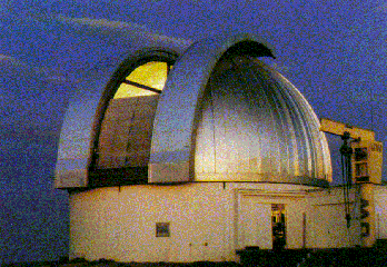
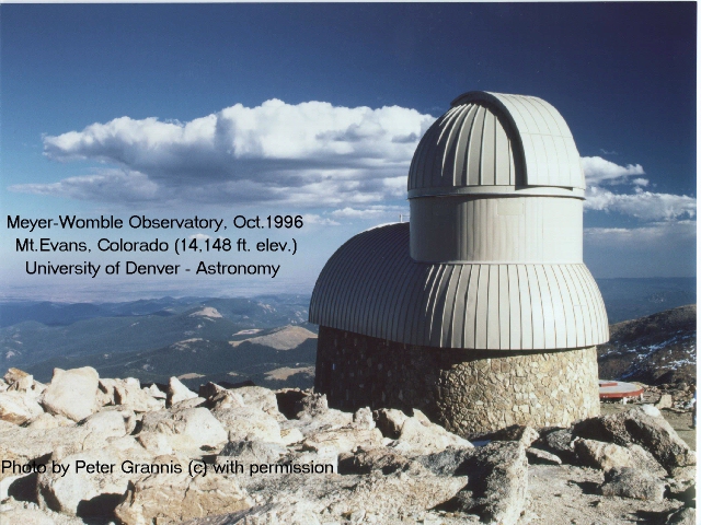
The Mt Evans Meyer-Womble Observatory is owned and operated by the Department of Physics and Astronomy, Denver University, whose hospitality we gratefully acknowledge. DU's claim to have the "world's highest operating observatory" is based on the official observatories listing that appears in theAstronomical Almanac. At 4,313 meters (Georgetown, CO), we are nearly 100 meters above the highest point listed for Mauna Kea(4,215 m), the nearest competitor. Still higher sites are either proposed or closed, but nothing else in North America comes close. The observatory is operated under a Special Use Permit granted by the USDA Forest Service. Mt.Evans is a 14,268 ft elevation peak situated in the Front Range of the Rocky Mountains, Colorado. It's relative isolation, approximately 15 miles east of the continental divide, provide some degree of drier, less cloudy and less windy conditions than those familiar to ski resort visitors. The new observatory is situated on a special useparcel near the end of the 14 mile paved state highway to the summit, and sits at 14,125 ft at its base, rising to a 14,165 ft apex. The University of Denver has conducted scientific programs atop Mt.Evans since the 1930s, and between anecdotal reports and the remote weather station data collected since 1992, reasonably complete descriptions now exist for annual variations intemperature, winds, humidity, snowfall patterns, sunlight and cloud cover. Conditions can become brutal at times, as atop any high mountain, but when conditions are favorable, they can be world-class quality for astronomy. As reported at recent meetings of the American Astronomical Society, astronomically useful conditions are observed more than 60% of the nights (about half of thesephotometric), and winds average 20-30 mph from the west-southwest direction, with highest winds noted in spring and autumn season changes (80 mph maximum). Although situated within line ofsight of a major metropolitan area, the 10,000 ft elevation gain over Denver helps limit the amount of light pollution that reaches the observatory view of the sky. Sky brightness measurements made in September 1994 found 21.5 mag/sq.arcsec, V band, zenith, which isonly 0.5 mag brighter than the naturally occurring background at all sites. Astronomical seeing, based on double stars, differential image motion monitoring and acoustic sounding, averages under one arcsecond. Infrared transparency to 27 microns has been characterized. Major challenges still facing the observatory include development of remote control, safe and reliable winter access and alternative power sources. Yucca Ridge Field Station
FMA Research, Inc. will operate a third ground observatory at Yucca Ridge, Colorado. The facilites and instrumentation of this observatory have been extensively described in the literature [Lyons, 1994a, Winckler et al., 1996]. The Yucca Ridge Field Station (YRFS) operated by FMA Research has hosted SPRITES observation campaigns each summer since 1993. It has recently greatly expanded its physical facilitiies by adding almost 2000 sq ft of climate controlled laboratory space including a large viewing platform with a commanding view of more than 400,000 sq km. Ideal viewing conditions allowed the 1996 campaign to record over 1100 sprites and elves during a five week cmapaign in July and August 1996. Scientific reserach teams from over a dozen organizations worked at YRFS to make coordinated optical and RF measurements of sprites and elves. The sensors successfully deployed included numerous low-light televisions, spectrometers, photomeetrs, fast imagers, and various ELF and VLF receiving systems. A 28 MHz radar was also deployed nearby. YRFS is set up for complete command and control functions associated with a mutli-site field program. Real time weather data support includes satellite delivered radar, weather satellite and lighting network data. Also, data are accessed and archived from the Internet onto dedicated workstation. Dedicated YRFS facilities include dual Xybion LLTV imagers, a pointing pohotometer, and several VLF receivers. It is hosting several additional VLF systems operated by Stanford University and the University of Otago. A cooperative ELF Schumann Resonance station is run in conjunction with MIT/Lincoln Labs. ELF, VLF and photometer data can be digitally sampled using high speed A/D system. All LLTV images are GPS time stamped and recorded on SVHS tapes, with four channel audio including voice annotation, VLF, ELF and WWV time. During SPRITES96, sprites and eleves were successfully imaged for distances out to 1000 km, and often coordinated with other LLTV sites in Wyoming (University of Alaska) and in New Mexico (NM Tech). Mission Reseach CorporationMission Research Corporation of Nashua, NH, will be oberving from Yucca Ridge during Sprites 99.
|
Copyright 1999, 2004, University of Houston
|